Cadastre Information System
Toggle Navigation
  • Home
  • Project Sites
    • Gapan Cadastre
    • Sta. Rosa Cadastre
  • Cadastral Databases
    • GCPs
      • NAMRIA
      • BLLMs
      • PBMs
      • CBMs
      • MBMs
      • BBMs
    • Maps
      • Topographic Maps
      • Land Information Maps
      • Cadastral Maps
      • Projection Maps
      • Tax Maps
      • Political Boundary Survey
    • Lotdata
      • Parcels
    • Boundary Maps
  • PSGC
    • Region
    • Province
    • Municipality / CIty
    • Barangay
  • r3.denr.gov.ph

Cradle Mountain

Details
Category: Scenery
Cradle Mountain

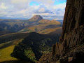
Read more: Cradle Mountain

Pinnacles

Details
Category: Scenery
Kings Canyon

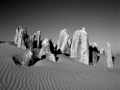
Read more: Pinnacles

Blue Mountain Rain Forest

Details
Category: Scenery
Rain Forest Blue Mountains

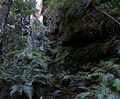
Read more: Blue Mountain Rain Forest

Ormiston Pound

Details
Category: Scenery
Ormiston Pound

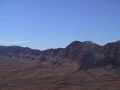
Read more: Ormiston Pound

  • You are here:  
  • Home
  • Image Gallery
  • Scenery

Sta Rosa Cadastre

  • Cadastre Home
  • Control Points
  • Maps
  • Project Blog
  • Image Gallery
    • Scenery
  • Project Links

Latest Cadastral Project Blogs

  • First Blog Post
  • Second Blog Post

Back to Top

© 2025 Cadastre Information System