 | |||
|---|---|---|---|
|
CADASTRAL SURVEY - Category "B" DEPARTMENT OF ENVIRONMENT AND NATURAL RESOURCES - REGION III |
Designation: BLLM-100 Page: 246 |
||
| THE POINT IS MEASURED AND PERMANENTLY MARKED IN 2014 | |||
|
CADASTRAL SURVEY NO: CAD-225 |
POLITICAL BOUNDARY SURVEY NO: PB-03-000045 |
||
|
GEOGRAPHIC COORDINATES (WGS 84) Φ = , λ = |
|
GEOGRAPHIC COORDINATES (PRS 92)
Φ = 15.22194556, λ = 120.93101400 |
|
|
GRID COORDINATES (PTM) in Meter N = 1706822.866, E = 492272.848 |
|
ELEVATION in Meter 0 Elipz Ht WGS84 = 56.145 Elipz Ht PRS92 = 0 |
|
|
CONTROL POINT Bureau of Lands Location Monument (BLLM) |
|||
| ISLAND: Luzon | CITY / MUNICIPALITY: | Gapan City | |
| PROVINCE: Nueva Ecija | BARANGAY: | ||
|
DESCRIPTION: Mark is the head of a 3” copper nail embedded and centered on a 25X25cm (top) by 35X35cm(base) by 120cm(height) standard concrete square base frustum, set on the ground with protruding 20 cm on the surface with inscriptions...”GAPAN CITY NEJ BLLM NO.100 CAD 225 DENR III 2014”. |
|||
|
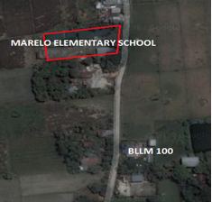
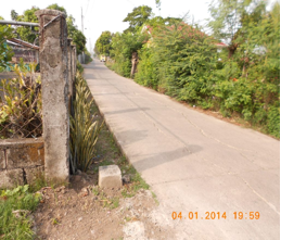
ACCESS: The monument is located along the barangay road beside a residential house and is approximately 60 meters away after the Marelo Elementary School. |
|||
|
SURVEYED / DESCRIBED BY:
|
DATE ESTABLISHED: | Sunday, 03 August 2014 05:49 | |
| PHOTO / SKETCH | |||
|
|
PICTURES: | ||
 |
|||
 |
|||
|
Caveat: This site and data herewith are for demonstration purposes only. Updates and Official/Actual Data can be acquired through DENR R3 LMS Office or call to inquire at (045) 455-3402. |
|||
| Monument Description Book (MDB) link | |||


